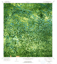
1974 Map of Thompson Pine Island
USGS Topo · Published 1993About this map
Thompson Pine Island serves as the central landmark for this orthophotomap of the Florida Everglades, capturing the intricate wetlands of Collier County in the early 1970s. The landscape is dominated by the winding path of Mullet Slough and the isolated waters of Mud Lake, interspersed with hammocks and mounded terrain. Remote outposts such as Osceola Camp and Wagon Wheel are visible, suggesting the limited human encroachment into these marshlands during this era.
Find a feature on this map
9 named features on this map. Tap any name to fly to it.
Don’t see what you’re looking for? This feature index may not catch every label — zoom into the map to look around manually.
Map Details
Editions of this 1974 Thompson Pine Island Map
2 editions found
Other maps of this area

1956 · Miami
USGS Topo · 1:250,000

1956 · West Palm Beach
USGS Topo · 1:250,000

1957 · West Palm Beach
USGS Topo · 1:250,000

1958 · West Palm Beach
USGS Topo · 1:250,000

1958 · Miami
USGS Topo · 1:250,000

1972 · Monroe Station NE
USGS Topo · 1:24,000

1972 · Burns Lake
USGS Topo · 1:24,000

1973 · North Of Fiftymile Bend
USGS Topo · 1:24,000

1974 · Immokalee 4 NW
USGS Topo · 1:24,000
1974 · Immokalee 4 SW
USGS Topo · 1:24,000