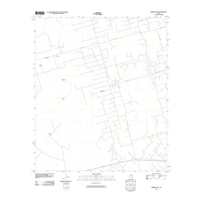
2010 Map of Imperial NW
USGS Topo · Published 2010About this map
The West Sand Hills Oil Field and Running W Oil Field define this portion of the Permian Basin landscape during the early 2010s. The map illustrates a network of industrial and ranching roads, including named corridors like Warren Plant Rd, Jim Tubbs Rd, and Exxon Loop that service the local petroleum infrastructure. This industrial presence is layered over a traditional ranching environment, marked by the Ell Long Ranch and several scattered water sources vital to the region's history, such as the R B Windmill, R B Valley Windmill, and Middle Windmill. The rectilinear grid of unpaved roads and pipeline access routes reveals the intensive resource extraction patterns that have long shaped the economic identity of Crane County.
Find a feature on this map
15 named features on this map. Tap any name to fly to it.
Don’t see what you’re looking for? This feature index may not catch every label — zoom into the map to look around manually.
Map Details
Editions of this 2010 Imperial NW Map
This is the sole edition of this map. No revisions or reprints were ever made.
Other maps of this area

1954 · Pecos
USGS Topo · 1:250,000

1957 · Pecos
USGS Topo · 1:250,000

1964 · Penwell SW
USGS Topo · 1:24,000

1964 · Penwell SE
USGS Topo · 1:24,000

1968 · Monahans SE
USGS Topo · 1:24,000

1969 · Ozark Lake
USGS Topo · 1:24,000

1969 · Grandfalls
USGS Topo · 1:24,000

1974 · Tubbs Corner
USGS Topo · 1:24,000

1974 · Juan Cordona Lake
USGS Topo · 1:24,000
1974 · Imperial NW
USGS Topo · 1:24,000