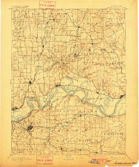
1894 Map of Independence
USGS Topo · Published 1901About this map
The Missouri River bisects this landscape, serving as a dynamic corridor for both rail and river traffic in the late nineteenth century. Established riverfront points like Liberty Landing and Missouri City appear alongside a network of competing railroads, including the Chicago and Alton Railroad and the Wabash Railroad. The river’s natural evolution is evident in features like Liberty Island and the oxbow waters of Cooley Lake, showing the shifting nature of the floodplain before modern channelization.
Find a feature on this map
107 named features on this map. Tap any name to fly to it.
Don’t see what you’re looking for? This feature index may not catch every label — zoom into the map to look around manually.
Map Details
Editions of this 1894 Independence Map
5 editions found

Other maps of this area

1885 · Warrensburg
USGS Topo · 1:125,000

1887 · Harrisonville
USGS Topo · 1:125,000

1887 · Olathe
USGS Topo · 1:125,000

1887 · Warrensburg
USGS Topo · 1:125,000

1889 · Lexington
USGS Topo · 1:125,000

1890 · Kansas City
USGS Topo · 1:125,000

1892 · Harrisonville
USGS Topo · 1:125,000

1893 · Olathe
USGS Topo · 1:125,000

1894 · Kansas City
USGS Topo · 1:125,000

1894 · Harrisonville
USGS Topo · 1:125,000