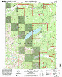
2000 Map of Independence Lake
USGS Topo · Published 2003About this map
Independence Lake sits as the central geographic feature of this Sierra Nevada landscape, surrounded by the high elevations of the Tahoe National Forest. The map documents a complex network of high-altitude water systems, including the Little Truckee River, Sagehen Creek, and the headwaters of Prosser Creek. This 2000 revision highlights the significance of modern conservation and recreation corridors, specifically tracing the Pacific Crest National Scenic Trail as it traverses the western ridges near Basin Peak and Mount Lola. The terrain is punctuated by a series of alpine meadows such as Cold Stream Meadow and Secret Meadow, which suggest the historic grazing and timber patterns of the region. The inclusion of the Henness Pass Road and the Fibreboard Road provides insight into the evolution of mountain transit, from 19th-century immigrant trails to 20th-century logging and forest management routes.
Find a feature on this map
40 named features on this map. Tap any name to fly to it.
Don’t see what you’re looking for? This feature index may not catch every label — zoom into the map to look around manually.
Map Details
Editions of this 2000 Independence Lake Map
This is the sole edition of this map. No revisions or reprints were ever made.
Other maps of this area

1890 · Sierraville
USGS Topo · 1:125,000

1891 · Truckee
USGS Topo · 1:125,000

1892 · Sierraville
USGS Topo · 1:125,000

1893 · Truckee
USGS Topo · 1:125,000

1894 · Sierraville
USGS Topo · 1:125,000

1895 · Truckee
USGS Topo · 1:125,000

1932 · Truckee
USGS Topo · 1:96,000

1940 · Truckee
USGS Topo · 1:125,000

1955 · Truckee
USGS Topo · 1:24,000

1955 · Loyalton
USGS Topo · 1:62,500