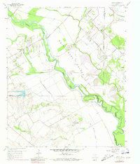
1959 Map of India
USGS Topo · Published 1980About this map
Bois D'arc Island dominates the landscape where the Trinity River winds through the borderlands of Dallas, Ellis, and Kaufman counties. This 1959 survey shows a riverine economy defined by gravel extraction and agriculture, with numerous gravel pits following the course of the river and its old sloughs. The settlement at India and the nearby community of Combine represent the rural residential patterns of the mid-20th century, supported by a network of farm-to-market roads like Malloy Bridge Road and Belt Line Road.
Find a feature on this map
38 named features on this map. Tap any name to fly to it.
Don’t see what you’re looking for? This feature index may not catch every label — zoom into the map to look around manually.
Map Details
Editions of this 1959 India Map
4 editions found
Other maps of this area

1891 · Dallas
USGS Topo · 1:125,000

1893 · Dallas
USGS Topo · 1:125,000

1954 · Dallas
USGS Topo · 1:250,000

1956 · Ennis
USGS Topo · 1:62,500

1956 · Kaufman
USGS Topo · 1:62,500

1958 · Dallas
USGS Topo · 1:250,000

1958 · Hutchins
USGS Topo · 1:24,000

1959 · Seagoville
USGS Topo · 1:24,000

1959 · Ferris
USGS Topo · 1:24,000

1959 · India
USGS Topo · 1:24,000