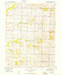
1949 Map of Indian Grove
USGS Topo · Published 1949About this map
The Atchison Topeka and Santa Fe railroad cuts across the northwestern corner of this landscape, following the path of Yellow Creek. This rural section of Chariton County is defined by a dense network of one-room schoolhouses and country churches that anchored the agrarian community in the late 1940s. Many of these institutions, such as North Newhall Sch, West Sch, and South Newhall Sch, are distributed across the township of Salt Creek, reflecting a time when education was localized and decentralized.
Find a feature on this map
28 named features on this map. Tap any name to fly to it.
Don’t see what you’re looking for? This feature index may not catch every label — zoom into the map to look around manually.
Map Details
Editions of this 1949 Indian Grove Map
4 editions found
Other maps of this area

1890 · Glasgow
USGS Topo · 1:125,000

1890 · Marshall
USGS Topo · 1:125,000

1892 · Marshall
USGS Topo · 1:125,000

1901 · Marshall
USGS Topo · 1:125,000

1949 · Mendon
USGS Topo · 1:24,000

1949 · Indian Grove
USGS Topo · 1:24,000

1949 · Sumner
USGS Topo · 1:24,000

1949 · Rothville
USGS Topo · 1:24,000

1950 · Sumner
USGS Topo · 1:24,000

1950 · Rothville
USGS Topo · 1:24,000