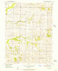
1949 Map of Indian Grove
USGS Topo · Published 1956About this map
Indian Grove and the small settlement of Newhall anchor this post-war landscape in Chariton County, defined by a dense network of country schools and churches. The rural infrastructure of the late 1940s is remarkably intact here, featuring numerous local landmarks such as North Newhall School, South Newhall School, and Woods School. Religious life is evidenced by the distribution of St Raphael Church, Zion Church, and Siloam Church. The northwestern corner is dominated by the Atchison Topeka and Santa Fe railroad corridor as it crosses Yellow Creek, providing a stark industrial contrast to the surrounding creek-cut topography. Genealogists can trace several burial sites across the township, including Old Mendon Cemetery and Newcomer Cemetery. The map captures a moment when the transition from traditional one-room schoolhouses like Newcomer School to consolidated systems was still visible on the land.
Find a feature on this map
30 named features on this map. Tap any name to fly to it.
Don’t see what you’re looking for? This feature index may not catch every label — zoom into the map to look around manually.
Map Details
Editions of this 1949 Indian Grove Map
4 editions found
Other maps of this area

1890 · Glasgow
USGS Topo · 1:125,000

1890 · Marshall
USGS Topo · 1:125,000

1892 · Marshall
USGS Topo · 1:125,000

1901 · Marshall
USGS Topo · 1:125,000

1949 · Mendon
USGS Topo · 1:24,000

1949 · Indian Grove
USGS Topo · 1:24,000

1949 · Sumner
USGS Topo · 1:24,000

1949 · Rothville
USGS Topo · 1:24,000

1950 · Sumner
USGS Topo · 1:24,000

1950 · Rothville
USGS Topo · 1:24,000