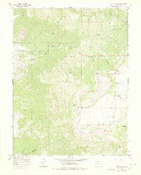
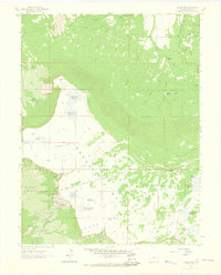
1965 Map of Indian Point
USGS Topo · Published 1978About this map
Grand Mesa National Forest dominates the high-altitude landscape of this mid-1960s survey, where the dramatic volcanic plateau breaks into sharp escarpments and deep drainage basins. The map illustrates a complex hydraulic system vital to the region, featuring Chambers Reservoir, Doughspoon Reservoir, and the high-water Blue Lake. At the southern edge of the mesa, Indian Point and Point Peninsula mark prominent overlooks above the Alkali Basin, while a remote Gaging Sta on Kannah Creek monitors the runoff from the snowy peaks. The presence of the Lands End Road and numerous pack trails, such as the Coal Creek Trail, underscores the area's transition from a strictly wild environment to one managed for water resources and seasonal access. For those tracing the history of western Colorado water rights or grazing land use, this sheet provides exact placement of long-standing infrastructure and named geographic markers like the Coal Creek Basin.
Find a feature on this map
36 named features on this map. Tap any name to fly to it.
Don’t see what you’re looking for? This feature index may not catch every label — zoom into the map to look around manually.
Map Details
Editions of this 1965 Indian Point Map
4 editions found
Other maps of this area

1955 · Skyway
USGS Topo · 1:24,000

1956 · Moab
USGS Topo · 1:250,000

1956 · Grand Junction
USGS Topo · 1:250,000

1959 · Grand Junction
USGS Topo · 1:250,000

1959 · Moab
USGS Topo · 1:250,000

1960 · Moab
USGS Topo · 1:250,000

1960 · Grand Junction
USGS Topo · 1:250,000

1962 · Moab
USGS Topo · 1:250,000

1962 · Grand Junction
USGS Topo · 1:250,000
1962 · Lands End
USGS Topo · 1:24,000