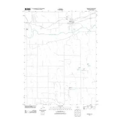
2011 Map of Indianola
USGS Topo · Published 2011About this map
Indianola serves as the primary hub of this Red Willow County landscape, situated where the Republican River and its tributaries define the regional geography. The settlement's civic and social history is grounded by the Indianola Post Office and local burial sites including Indianola Cemetery and Saint Catherine Cemetery. The map reveals a complex irrigation and water management network vital to the plains economy, evidenced by the Red Willow Canal and the Red Willow Canal Rd. To the south and east, a series of private reservoirs and dams—such as Sughrone Reservoir Number 2, Schaffert Reservoir, and Quigley Reservoir—illustrate how the drainage basins of Buffalo Creek and Berger Creek have been modified to support agriculture. Further west, the smaller settlement of Red Willow marks the confluence of Red Willow Creek and the river valley.
Find a feature on this map
26 named features on this map. Tap any name to fly to it.
Don’t see what you’re looking for? This feature index may not catch every label — zoom into the map to look around manually.
Map Details
Editions of this 2011 Indianola Map
This is the sole edition of this map. No revisions or reprints were ever made.
Other maps of this area

1954 · McCook
USGS Topo · 1:250,000

1956 · Bartley
USGS Topo · 1:24,000

1957 · McCook
USGS Topo · 1:250,000

1957 · Danbury
USGS Topo · 1:24,000

1957 · Lebanon
USGS Topo · 1:24,000

1957 · McCook SE
USGS Topo · 1:24,000

1957 · Danbury NE
USGS Topo · 1:24,000

1958 · McCook
USGS Topo · 1:250,000

1958 · Danbury NE
USGS Topo · 1:24,000
1958 · Indianola
USGS Topo · 1:24,000