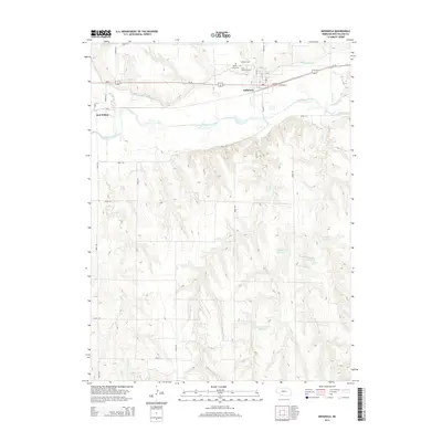
2014 Map of Indianola
USGS Topo · Published 2014About this map
Indianola and the small settlement of Red Willow sit at the northern edge of this Red Willow County landscape, where the Republican River valley dictates the local geography and infrastructure. The area is defined by an extensive irrigation network, including the Red Willow Canal and Bartley Canal, which divert water to support the agricultural economy of the plains. Further south, the terrain becomes more complex as numerous drainages like Ash Cr, Buffalo Cr, and Berger Cr carve through the land, feeding several private and agricultural water bodies such as Sughrone Reservoir Number 2 and Schaffert Reservoir. For genealogists and local historians, the cluster of burial sites near the main townsite is significant, featuring Indianola Cem, Cedar Grove Cem, and Saint Catherine Cem. These locations, along with the grid-based road network of Road 719 and Road 392, provide a clear picture of rural Nebraska land use and communal heritage.
Find a feature on this map
36 named features on this map. Tap any name to fly to it.
Don’t see what you’re looking for? This feature index may not catch every label — zoom into the map to look around manually.
Map Details
Editions of this 2014 Indianola Map
This is the sole edition of this map. No revisions or reprints were ever made.
Other maps of this area

1954 · McCook
USGS Topo · 1:250,000

1956 · Bartley
USGS Topo · 1:24,000

1957 · McCook
USGS Topo · 1:250,000

1957 · Danbury
USGS Topo · 1:24,000

1957 · Lebanon
USGS Topo · 1:24,000

1957 · McCook SE
USGS Topo · 1:24,000

1957 · Danbury NE
USGS Topo · 1:24,000

1958 · McCook
USGS Topo · 1:250,000

1958 · Danbury NE
USGS Topo · 1:24,000
1958 · Indianola
USGS Topo · 1:24,000