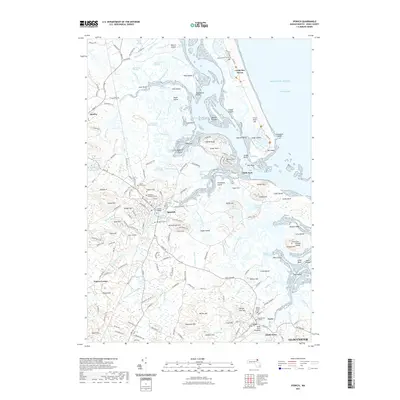
2021 Map of Ipswich
USGS Topo · Published 2021About this map
Ipswich and its intricate coastal geography dominate this 2021 study, where the Ipswich River meets the Atlantic Ocean through a network of tidal marshes and drumlin hills. The town’s long history is reflected in its numerous historic interment sites, including the Old North Burying Ground and Highland Cemetery, as well as the landmark Choate Bridge spanning the river downtown. To the north, the Parker River Marshes and Roger Island River Marshes create a vast mosaic of wetlands broken by glacial features like Eagle Hill and the Hog Islands. Along the coast, the landscape transitions from the sandy expanse of Crane Beach and Castle Neck to the rocky outcrops of Emersons Rocks. Further south, the settlement of Essex is detailed near the Essex Burial Ground and the South Essex waterfront, illustrating the persistent maritime and colonial character of this Essex County region.
Find a feature on this map
209 named features on this map. Tap any name to fly to it.
Don’t see what you’re looking for? This feature index may not catch every label — zoom into the map to look around manually.
Map Details
Editions of this 2021 Ipswich Map
This is the sole edition of this map. No revisions or reprints were ever made.
Other maps of this area

1886 · Gloucester
USGS Topo · 1:62,500

1888 · Newburyport
USGS Topo · 1:62,500

1888 · Gloucester
USGS Topo · 1:62,500

1888 · Salem
USGS Topo · 1:62,500

1890 · Newburyport
USGS Topo · 1:62,500

1893 · Salem
USGS Topo · 1:62,500

1893 · Gloucester
USGS Topo · 1:62,500

1894 · Newburyport
USGS Topo · 1:62,500

1917 · Salem
USGS Topo · 1:62,500

1918 · Gloucester
USGS Topo · 1:62,500