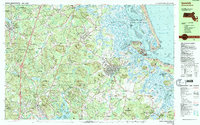
1985 Map of Ipswich
USGS Topo · Published 1986About this map
The coastal marshes and glacial drumlins of Essex County define this 1985 landscape, where the historic town of Ipswich serves as a central hub between the interior forests and the Atlantic shore. To the east, the complex estuary system of Plum Island Sound and the Parker River National Wildlife Refuge protect a labyrinth of tidal creeks like Great Creek and barrier beaches including Plum Island. The presence of Governor Dummer Academy and several religious institutions, such as the Sisters of Notre Dame de Namur Novitiate, reflects the area's long-standing educational and spiritual heritage.
Find a feature on this map
166 named features on this map. Tap any name to fly to it.
Don’t see what you’re looking for? This feature index may not catch every label — zoom into the map to look around manually.
Map Details
Editions of this 1985 Ipswich Map
3 editions found
Other maps of this area

1886 · Gloucester
USGS Topo · 1:62,500

1886 · Lawrence
USGS Topo · 1:62,500

1888 · Newburyport
USGS Topo · 1:62,500

1888 · Haverhill
USGS Topo · 1:62,500

1888 · Gloucester
USGS Topo · 1:62,500

1888 · Lawrence
USGS Topo · 1:62,500

1888 · Salem
USGS Topo · 1:62,500

1890 · Haverhill
USGS Topo · 1:62,500

1890 · Newburyport
USGS Topo · 1:62,500

1893 · Salem
USGS Topo · 1:62,500