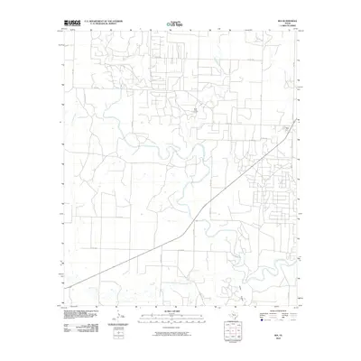
2010 Map of Ira
USGS Topo · Published 2010About this map
The settlement of Ira anchors the eastern edge of this Scurry County landscape, where the high plains begin their descent toward the winding Colorado River. This river course, along with its intermittent tributaries like Bull Creek and Bluff Creek, carves a distinct path through the West Texas terrain. For genealogists and local historians, the Bluff Creek Cemetery serves as a significant landmark north of the river, while the land to the south is marked by the rugged topography of Cedar Canyon and the path of Willow Creek. The map documents a sparse but essential network of rural infrastructure, including Sterling Rd and Ranch Rd 1229, which connect isolated homesteads and ranching tracts. The layout of county roads reveals a transition from the rigid grid of the upper plains to a more fluid alignment that follows the natural breaks and canyons of the river valley.
Find a feature on this map
29 named features on this map. Tap any name to fly to it.
Don’t see what you’re looking for? This feature index may not catch every label — zoom into the map to look around manually.
Map Details
Editions of this 2010 Ira Map
This is the sole edition of this map. No revisions or reprints were ever made.
Other maps of this area

1950 · Cedar Bend
USGS Topo · 1:24,000

1951 · Ira SW
USGS Topo · 1:24,000

1951 · Ira
USGS Topo · 1:24,000

1951 · Dunn
USGS Topo · 1:24,000

1951 · Ira NW
USGS Topo · 1:24,000

1951 · Vincent
USGS Topo · 1:24,000

1952 · Cuthbert
USGS Topo · 1:24,000

1952 · Snyder
USGS Topo · 1:24,000

1952 · Ira NE
USGS Topo · 1:24,000

1954 · Big Spring
USGS Topo · 1:250,000