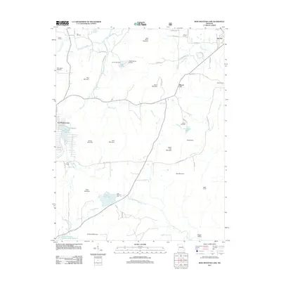
2011 Map of Iron Mountain Lake
USGS Topo · Published 2011About this map
Iron Mountain Lake and the settlement of Doe Run anchor this portion of Saint Francois County, where the eastern Ozark landscape is defined by a dense concentration of named peaks and water management systems. The terrain is marked by prominent heights including Stono Mountain, Anderson Mountain, and Tribby Mountain, with drainage provided by the Saint Francis River and Indian Creek. Industrial and aviation markers are evident, from the Pilot Knob Pellet Company Lake Number 2 to the Dove Airstrip south of the main lake. For genealogists, the map preserves the locations of several burial grounds, such as German Cemetery near Doe Run Creek and Weiss Cemetery on the eastern edge of the quadrangle. The distribution of dams, including the Black Upper Lake Dam and Sylvan Lake Dam, reflects a landscape heavily modified for water control and recreation in the early twenty-first century.
Find a feature on this map
62 named features on this map. Tap any name to fly to it.
Don’t see what you’re looking for? This feature index may not catch every label — zoom into the map to look around manually.
Map Details
Editions of this 2011 Iron Mountain Lake Map
This is the sole edition of this map. No revisions or reprints were ever made.
Other maps of this area

1904 · Farmington
USGS Topo · 1:62,500

1905 · Bonneterre
USGS Topo · 1:62,500

1906 · Farmington
USGS Topo · 1:62,500

1937 · Ironton
USGS Topo · 1:48,000

1939 · Fredericktown
USGS Topo · 1:48,000

1945 · Ironton
USGS Topo · 1:62,500

1946 · Ironton
USGS Topo · 1:62,500

1947 · Fredericktown
USGS Topo · 1:62,500

1949 · Rolla
USGS Topo · 1:250,000

1950 · Fredericktown
USGS Topo · 1:62,500