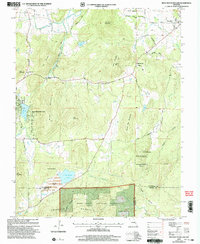
2000 Map of Iron Mountain Lake
USGS Topo · Published 2003About this map
Iron Mountain Lake and the surrounding peaks of the St. Francois Mountains dominate this landscape at the turn of the millennium. The terrain is marked by significant industrial and natural features, from the legacy of mineral extraction visible at Doe Run and the large Tailings Pond near Pilot Knob Lake, to the protected timberlands of the Mark Twain National Forest. The map captures a transition between the established community at Mineral City and the more dispersed settlements tucked into the hollows. Genealogists will find several burial grounds, including the German Cem, Grieder Cem, and Dent Cem. Waterways like the St Francis River and Indian Creek weave between prominent elevations such as Little Stone Mountain and Bread Tray Mountain. This survey provides a clear view of the road network connecting these remote sites, including Old Vandergriff Rd and Buck Mountain Road.
Find a feature on this map
52 named features on this map. Tap any name to fly to it.
Don’t see what you’re looking for? This feature index may not catch every label — zoom into the map to look around manually.
Map Details
Editions of this 2000 Iron Mountain Lake Map
This is the sole edition of this map. No revisions or reprints were ever made.
Other maps of this area

1904 · Farmington
USGS Topo · 1:62,500

1905 · Bonneterre
USGS Topo · 1:62,500

1906 · Farmington
USGS Topo · 1:62,500

1937 · Ironton
USGS Topo · 1:48,000

1939 · Fredericktown
USGS Topo · 1:48,000

1945 · Ironton
USGS Topo · 1:62,500

1946 · Ironton
USGS Topo · 1:62,500

1947 · Fredericktown
USGS Topo · 1:62,500

1949 · Rolla
USGS Topo · 1:250,000

1950 · Fredericktown
USGS Topo · 1:62,500