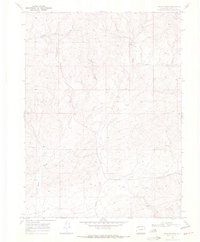
1969 Map of Iron Springs
USGS Topo · Published 1972About this map
Iron Springs and the drainage of Lay Creek dominate this 1960s landscape in Moffat County. The terrain is defined by a network of seasonal watercourses and deep incisions including Bord Gulch and Dressler Gulch, illustrating the high-desert topography of Northwest Colorado. Evidence of resource exploration is scattered throughout the survey, with several markers for an Oil Well and specific survey points like Drill Hole 6758. These industrial features, alongside numerous instances of a simple Well or Spring, suggest a landscape where water and mineral rights were central to local land use. This survey captures a moment of quiet industrial activity before more modern developments altered the region's character.
Find a feature on this map
11 named features on this map. Tap any name to fly to it.
Don’t see what you’re looking for? This feature index may not catch every label — zoom into the map to look around manually.
Map Details
Editions of this 1969 Iron Springs Map
2 editions found
Other maps of this area

1916 · Craig
USGS Topo · 1:125,000

1954 · Craig
USGS Topo · 1:250,000

1957 · Craig
USGS Topo · 1:250,000

1958 · Craig
USGS Topo · 1:250,000

1960 · Craig
USGS Topo · 1:250,000

1962 · Craig
USGS Topo · 1:250,000

1964 · Craig
USGS Topo · 1:250,000

1965 · Craig
USGS Topo · 1:250,000
1969 · Adobe Springs
USGS Topo · 1:24,000
1969 · Great Divide
USGS Topo · 1:24,000