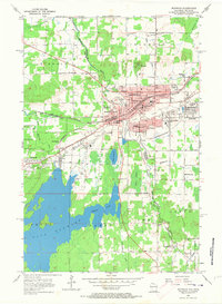
1955 Map of Ironwood
USGS Topo · Published 1973About this map
The iron mining legacy of the Gogebic Range is strikingly evident along the border of Michigan and Wisconsin. The Twin Cities of Ironwood and Hurley serve as the central hub, bisected by the Montreal River. Industrial activity is marked by the Cary Mine and numerous unnamed mine dumps and sunken areas that speak to the subsurface extraction defining this era. The massive Gile Flowage Reservoir dominates the southwest, providing a stark contrast to the dense network of neighborhoods like Jessieville, Aurora, and Norrie.
Find a feature on this map
51 named features on this map. Tap any name to fly to it.
Don’t see what you’re looking for? This feature index may not catch every label — zoom into the map to look around manually.
Map Details
Editions of this 1955 Ironwood Map
5 editions found
Other maps of this area

1940 · Upson
USGS Topo · 1:48,000

1943 · Little Girls Point
USGS Topo · 1:24,000

1943 · Upson
USGS Topo · 1:48,000

1943 · Ironwood
USGS Topo · 1:48,000

1943 · Little Girl Point
USGS Topo · 1:48,000

1953 · Ashland
USGS Topo · 1:250,000

1955 · Ironwood
USGS Topo · 1:24,000

1955 · Bessemer
USGS Topo · 1:24,000

1955 · Ironwood
USGS Topo · 1:62,500

1956 · North Ironwood
USGS Topo · 1:62,500