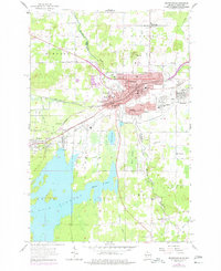
1955 Map of Ironwood
USGS Topo · Published 1977About this map
Ironwood and Hurley straddle the state line along the Montreal River in this mid-century survey, revealing a landscape shaped by mining, rail, and the border itself. The urban core is densely marked with civic infrastructure including City Hall, the Armory, and a network of neighborhood institutions like Murphy High Sch, Central Sch, and St Marys Cemetery. To the south, the expansive Gile Flowage dominates the terrain, while the residential outskirts reach toward Jessieville and Norrie. Industry and recreation appear side-by-side, from the numerous Gravel Pits to the leisure sites of Mt Zion Park and the local Drive-in Theater. The complex rail network, including the Chicago and North Western and Minneapolis St Paul and Sault Ste Marie, traces the legacy of the Gogebic Range's industrial peak.
Find a feature on this map
53 named features on this map. Tap any name to fly to it.
Don’t see what you’re looking for? This feature index may not catch every label — zoom into the map to look around manually.
Map Details
Editions of this 1955 Ironwood Map
5 editions found
Other maps of this area

1940 · Upson
USGS Topo · 1:48,000

1943 · Little Girls Point
USGS Topo · 1:24,000

1943 · Upson
USGS Topo · 1:48,000

1943 · Ironwood
USGS Topo · 1:48,000

1943 · Little Girl Point
USGS Topo · 1:48,000

1953 · Ashland
USGS Topo · 1:250,000

1955 · Ironwood
USGS Topo · 1:24,000

1955 · Bessemer
USGS Topo · 1:24,000

1955 · Ironwood
USGS Topo · 1:62,500

1956 · North Ironwood
USGS Topo · 1:62,500