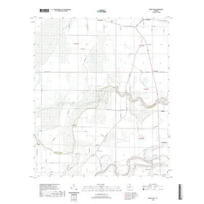
2020 Map of Irwin Lake
USGS Topo · Published 2020About this map
Oak Ridge and the surrounding plantation country of Louisiana's northeast corner are defined by the intricate waterways of Morehouse Parish and Richland Parish. The Boeuf River winds along the southern boundary, its course flanked by smaller tributaries such as Alligator Bayou and Como Bayou. This landscape is marked by numerous family and community landmarks, including Conger Cem, New Salem Cem, and James Chapel Cem, which reflect the deep roots of local settlements like Bordenax, Bardel, and White Island. The terrain transitions from the elevated ground of Gum Ridge in the north to the low-lying wetlands of Cooks Slough and Irwin Lake. This survey illustrates a network of rural roads, such as Buck Shepard Rd and George Franklin Rd, that connect these isolated agricultural communities across the delta's alluvial plain.
Find a feature on this map
76 named features on this map. Tap any name to fly to it.
Don’t see what you’re looking for? This feature index may not catch every label — zoom into the map to look around manually.
Map Details
Editions of this 2020 Irwin Lake Map
This is the sole edition of this map. No revisions or reprints were ever made.
Other maps of this area

1935 · Collinston
USGS Topo · 1:62,500

1935 · Alto
USGS Topo · 1:62,500

1935 · Baskinton
USGS Topo · 1:62,500

1935 · Hurricane
USGS Topo · 1:62,500

1955 · Jackson
USGS Topo · 1:250,000

1957 · Mangham
USGS Topo · 1:62,500

1957 · Collinston
USGS Topo · 1:62,500

1958 · Baskinton
USGS Topo · 1:62,500

1958 · Hurricane
USGS Topo · 1:62,500

1961 · Jackson
USGS Topo · 1:250,000