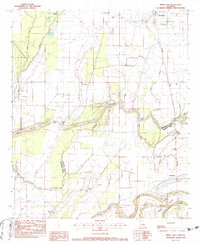
1982 Map of Irwin Lake
USGS Topo · Published 1983About this map
Lafourche Bayou meanders through the heart of the northeastern Louisiana delta, forming a complex hydrologic network of lakes and sloughs along the Morehouse Parish Richland Parish line. In the early 1980s, this landscape was defined by the intersection of traditional agricultural settlements and industrial energy extraction, visible in the sprawling Monroe Gas Field to the west. Local life centers on small communities like Oak Ridge, Bardel, and Jonesburg, each anchored by historical rural institutions. Genealogists will find a high density of rural burial grounds and houses of worship, including Irwin Lake Cem, New Salem Cem, and James Chapel Cem, alongside St Luke Ch and Alexandria Ch No 2. The Missouri Pacific railroad cuts through the eastern terrain, reflecting the long-standing transport patterns of the region's river-and-rail economy.
Find a feature on this map
36 named features on this map. Tap any name to fly to it.
Don’t see what you’re looking for? This feature index may not catch every label — zoom into the map to look around manually.
Map Details
Editions of this 1982 Irwin Lake Map
This is the sole edition of this map. No revisions or reprints were ever made.
Other maps of this area

1935 · Collinston
USGS Topo · 1:62,500

1935 · Alto
USGS Topo · 1:62,500

1935 · Baskinton
USGS Topo · 1:62,500

1935 · Hurricane
USGS Topo · 1:62,500

1955 · Jackson
USGS Topo · 1:250,000

1957 · Mangham
USGS Topo · 1:62,500

1957 · Collinston
USGS Topo · 1:62,500

1958 · Baskinton
USGS Topo · 1:62,500

1958 · Hurricane
USGS Topo · 1:62,500

1961 · Jackson
USGS Topo · 1:250,000