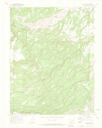
1969 Map of Island Mesa
USGS Topo · Published 1973About this map
Island Mesa dominates this 1969 topographic study, showcasing the complex high-desert plateau and canyon systems of western Colorado. The landscape is defined by deep incisions like Bangs Canyon and Rough Canyon, which break the flat tops of Horse Mesa and Clarks Bench. Human activity in this period appears concentrated on transit and resource extraction, evidenced by the numerous Jeep Trails spidering across the terrain and the presence of Claypits in the northwest. Water sources are critical landmarks in this arid environment, with mapped points such as Corduroy Spring, Notch Spring, and West Springs providing vital relief. In the far northeast, the Gunnison River clips the corner of the quadrangle, while North East Creek and Unaweep East Creek drain the southern reaches near Ninemile Hill.
Find a feature on this map
21 named features on this map. Tap any name to fly to it.
Don’t see what you’re looking for? This feature index may not catch every label — zoom into the map to look around manually.
Map Details
Editions of this 1969 Island Mesa Map
4 editions found
Other maps of this area

1934 · Colorado National Monument
USGS Topo · 1:24,000

1956 · Moab
USGS Topo · 1:250,000

1956 · Grand Junction
USGS Topo · 1:250,000

1959 · Grand Junction
USGS Topo · 1:250,000

1959 · Moab
USGS Topo · 1:250,000

1960 · Moab
USGS Topo · 1:250,000

1960 · Grand Junction
USGS Topo · 1:250,000

1962 · Moab
USGS Topo · 1:250,000

1962 · Grand Junction
USGS Topo · 1:250,000

1962 · Clifton
USGS Topo · 1:24,000