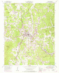
1953 Map of Iuka
USGS Topo · Published 1974About this map
Iuka serves as the focal point of this Tishomingo County survey, where the Southern Railway and Lee Highway converge near the Mineral Springs Park. The landscape is defined by its numerous small hollows and ridges, leading toward the high point of Woodall Mtn in the southwest. The map documents a rural infrastructure of family-named landmarks and local institutions, including the John M Stone Memorial Marker and schools like the Bennett Chapel School and Eastport Sch.
Find a feature on this map
62 named features on this map. Tap any name to fly to it.
Don’t see what you’re looking for? This feature index may not catch every label — zoom into the map to look around manually.
Map Details
Editions of this 1953 Iuka Map
3 editions found
Other maps of this area

1911 · Iuka
USGS Topo · 1:48,000

1914 · Iuka
USGS Topo · 1:62,500

1935 · Holcut
USGS Topo · 1:24,000

1935 · Doskie
USGS Topo · 1:24,000

1935 · Iuka
USGS Topo · 1:24,000

1935 · Leedy
USGS Topo · 1:24,000

1936 · Margerum
USGS Topo · 1:24,000

1936 · Waterloo
USGS Topo · 1:24,000

1936 · Shaws
USGS Topo · 1:24,000

1936 · Bishop
USGS Topo · 1:24,000