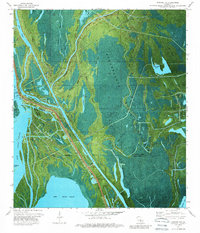
1973 Map of Jackass Bay
USGS Topo · Published 1989About this map
Lake Fausse Pointe and the surrounding wetlands of the Atchafalaya Basin Floodway define this landscape during the early 1970s. The region is a dense network of waterways, where larger bodies like Dauterive Lake and Grand Lake are linked by a labyrinth of bayous, including the curiously named Four Hundred Dollar Bayou, Little Gonsoulin Bayou, and Alligator Bayou. Human activity is centered on the water, evidenced by the Grand Bayou Mission and various infrastructure such as a Platform, Pier, and Boat Ramp near the southern shore of Dauterive Lake. The map captures an era of industrial extraction within the swamp, marking the Chicot Gas Field and scattered Oil Wells amidst the cypress and tupelo terrain. Distinctive landmarks like Mestayer Point and Eagle Point provide navigational reference points along the parish line between St. Martin Parish and Iberia Parish.
Find a feature on this map
42 named features on this map. Tap any name to fly to it.
Don’t see what you’re looking for? This feature index may not catch every label — zoom into the map to look around manually.
Map Details
Editions of this 1973 Jackass Bay Map
3 editions found
Other maps of this area

1935 · Chicot Lake
USGS Topo · 1:62,500

1937 · Jeanerette
USGS Topo · 1:62,500

1941 · Loreauville
USGS Topo · 1:62,500

1945 · New Orleans
USGS Topo · 1:250,000

1948 · Foster
USGS Topo · 1:62,500

1953 · Pigeon Bay
USGS Topo · 1:24,000

1954 · Chicot Lake
USGS Topo · 1:62,500

1954 · Loreauville
USGS Topo · 1:62,500

1954 · Jeanerette
USGS Topo · 1:62,500

1954 · Baton Rouge
USGS Topo · 1:250,000