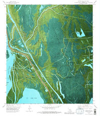
1973 Map of Jackass Bay
USGS Topo · Published 1989About this map
Lake Fausse Pointe and the expansive Atchafalaya Basin Floodway define this 1970s landscape on the border of St Martin Parish and Iberia Parish. This orthophotomap combines aerial photography with topographic detail, revealing the complex hydraulic environment of the Louisiana swamp. The Fausse Pointe Cut serves as a primary navigation corridor, while smaller waterways like Bayou Gonsoulin and Four Hundred Dollar Bayou create a dense web of wetlands. Human activity in this saturated terrain is concentrated at the Grand Bayou Mission and the industrial infrastructure of the Chicot Gas Field. Scattered Oil Wells and a network of pipelines illustrate the mid-century energy production established within the basin. Distinct landmarks such as Mestayer Point and Crook Chene Cove mark the transition from open lake to dense cypress-tupelo forest.
Find a feature on this map
38 named features on this map. Tap any name to fly to it.
Don’t see what you’re looking for? This feature index may not catch every label — zoom into the map to look around manually.
Map Details
Editions of this 1973 Jackass Bay Map
3 editions found
Other maps of this area

1935 · Chicot Lake
USGS Topo · 1:62,500

1937 · Jeanerette
USGS Topo · 1:62,500

1941 · Loreauville
USGS Topo · 1:62,500

1945 · New Orleans
USGS Topo · 1:250,000

1948 · Foster
USGS Topo · 1:62,500

1953 · Pigeon Bay
USGS Topo · 1:24,000

1954 · Chicot Lake
USGS Topo · 1:62,500

1954 · Loreauville
USGS Topo · 1:62,500

1954 · Jeanerette
USGS Topo · 1:62,500

1954 · Baton Rouge
USGS Topo · 1:250,000