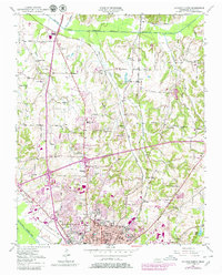
1950 Map of Jackson North
USGS Topo · Published 1980About this map
Jackson anchors this landscape as it appeared at mid-century, reflecting the post-war growth of Madison County along the Illinois Central Gulf Railroad. The northern expansion of the city is evident, pushing toward new residential developments like Westwood Gardens and Poplar Heights. Educational and civic foundations are well-documented, from the historic Lane College campus and Jackson High Sch to local landmarks like the General Hospital.
Find a feature on this map
66 named features on this map. Tap any name to fly to it.
Don’t see what you’re looking for? This feature index may not catch every label — zoom into the map to look around manually.
Map Details
Editions of this 1950 Jackson North Map
5 editions found
Other maps of this area

1950 · Jackson South
USGS Topo · 1:24,000

1950 · Jackson North
USGS Topo · 1:24,000

1951 · Jackson North
USGS Topo · 1:24,000

1953 · Claybrook
USGS Topo · 1:24,000

1953 · Beech Bluff
USGS Topo · 1:24,000

1956 · Blytheville
USGS Topo · 1:250,000

1959 · Medina
USGS Topo · 1:24,000

1959 · Blytheville
USGS Topo · 1:250,000

1959 · Westover
USGS Topo · 1:24,000

1959 · Adair
USGS Topo · 1:24,000