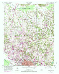
1950 Map of Jackson North
USGS Topo · Published 1984About this map
Jackson and its northern outskirts are dominated by a landscape where the South Fork Forked Deer River and its tributaries, such as Turkey Creek and Moize Creek, carve through the rolling terrain. The mid-20th-century development of the area is anchored by institutional landmarks including Lane College, Jackson High Sch, and the General Hospital. Transportation patterns are defined by the Illinois Central Gulf Railroad, which parallels many of the region’s primary routes, linking the urban center to smaller outlying communities like Oakfield and Youngs Crossing.
Find a feature on this map
36 named features on this map. Tap any name to fly to it.
Don’t see what you’re looking for? This feature index may not catch every label — zoom into the map to look around manually.
Map Details
Editions of this 1950 Jackson North Map
5 editions found
Other maps of this area

1950 · Jackson South
USGS Topo · 1:24,000

1950 · Jackson North
USGS Topo · 1:24,000

1951 · Jackson North
USGS Topo · 1:24,000

1953 · Claybrook
USGS Topo · 1:24,000

1953 · Beech Bluff
USGS Topo · 1:24,000

1956 · Blytheville
USGS Topo · 1:250,000

1959 · Medina
USGS Topo · 1:24,000

1959 · Blytheville
USGS Topo · 1:250,000

1959 · Westover
USGS Topo · 1:24,000

1959 · Adair
USGS Topo · 1:24,000