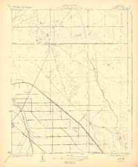
1924 Map of Jamesan
USGS Topo · Published 1924About this map
Jamesan and Tranquillity appear as the primary hubs of this agricultural landscape in the San Joaquin Valley during the early 1920s. The region is defined by an intricate network of water management features, including the Main Bypass, Slough, and the Enterprise Canal, which support the transition of the arid terrain into productive farmland. The Southern Pacific railroad cuts through the territory, providing a critical transport link for local produce and settlers alike.
Find a feature on this map
10 named features on this map. Tap any name to fly to it.
Don’t see what you’re looking for? This feature index may not catch every label — zoom into the map to look around manually.
Map Details
Editions of this 1924 Jamesan Map
2 editions found
Other maps of this area

1921 · Mendota
USGS Topo · 1:31,680

1923 · Englebrecht Ranch
USGS Topo · 1:31,680

1923 · Biola
USGS Topo · 1:31,680

1924 · Jamesan
USGS Topo · 1:31,680

1924 · Tranquillity
USGS Topo · 1:31,680

1924 · Gravelly Ford
USGS Topo · 1:31,680

1924 · Mendota
USGS Topo · 1:31,680

1925 · Helm
USGS Topo · 1:31,680

1925 · San Joaquin
USGS Topo · 1:31,680

1946 · Tranquillity
USGS Topo · 1:62,500