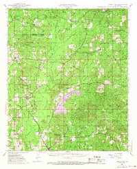
1948 Map of Jamestown
USGS Topo · Published 1968About this map
Deep piney woods and agricultural clearings define this portion of the Webster Parish Bienville Parish line during the mid-century. The landscape is heavily influenced by the extraction economy of the Lucky Gas Field, where numerous gas and oil wells are connected by an expanding Pipeline network. Central to the topography is Kepler Creek Lake, a significant water body fed by Kepler Creek and Black Bayou. The Louisiana and Arkansas Railway serves as the primary industrial artery, passing through the southern settlement of Castor.
Find a feature on this map
64 named features on this map. Tap any name to fly to it.
Don’t see what you’re looking for? This feature index may not catch every label — zoom into the map to look around manually.
Map Details
Editions of this 1948 Jamestown Map
3 editions found
Other maps of this area

1947 · Ringgold
USGS Topo · 1:62,500

1947 · Goldonna
USGS Topo · 1:62,500

1947 · Ashland
USGS Topo · 1:62,500

1947 · Bienville
USGS Topo · 1:62,500

1947 · Minden
USGS Topo · 1:62,500

1948 · Coushatta
USGS Topo · 1:62,500

1948 · Jamestown
USGS Topo · 1:62,500

1949 · Jamestown
USGS Topo · 1:62,500

1949 · Bienville
USGS Topo · 1:62,500

1949 · Minden
USGS Topo · 1:62,500