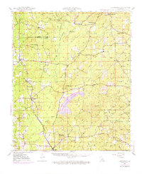
1948 Map of Jamestown
USGS Topo · Published 1976About this map
The Louisiana and Arkansas Railway cuts a vital diagonal through this North Louisiana landscape, connecting rural hubs like Jamestown and Castor during a period of significant petroleum development. The map reveals a dense network of energy extraction, highlighted by the Ada Oil and Gas Field in the north and the Lucky Gas Field to the southeast. These industrial features contrast with the deeply rooted social fabric of the parish, evidenced by the numerous country schools and churches like Ebenezer School, Madden Church, and New Friendship Church No 1. Significant water bodies and drainages, including Kepler Lake and Black Lake Bayou, define the low-lying terrain. For genealogists, the map is a primary source for locating family-named sites such as Salles and the Game Cem, alongside civil landmarks like the Salles Lookout Tower.
Find a feature on this map
87 named features on this map. Tap any name to fly to it.
Don’t see what you’re looking for? This feature index may not catch every label — zoom into the map to look around manually.
Map Details
Editions of this 1948 Jamestown Map
3 editions found
Other maps of this area

1947 · Ringgold
USGS Topo · 1:62,500

1947 · Goldonna
USGS Topo · 1:62,500

1947 · Ashland
USGS Topo · 1:62,500

1947 · Bienville
USGS Topo · 1:62,500

1947 · Minden
USGS Topo · 1:62,500

1948 · Coushatta
USGS Topo · 1:62,500

1948 · Jamestown
USGS Topo · 1:62,500

1949 · Jamestown
USGS Topo · 1:62,500

1949 · Bienville
USGS Topo · 1:62,500

1949 · Minden
USGS Topo · 1:62,500