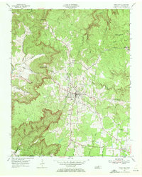
1954 Map of Jamestown
USGS Topo · Published 1972About this map
Jamestown stands at the heart of this mid-century topographic study, appearing as a developed highland hub on the Cumberland Plateau during the mid-1950s. The presence of the Alvin C York Institute and the nearby settlement of Alvin reflect the local legacy of World War I hero Alvin C. York. To the east, Allardt and East Jamestown are connected by the regional road network, while the landscape beyond the town centers is defined by steep drainage systems like Crooked Creek and Rockcastle Creek. Numerous small burial grounds, including Livingston Cem and Taylor Cem, are scattered across the plateau, providing essential data for genealogical research. Cultural and industrial features of the era are well-documented, from a Drive-in Theater north of town to an abandoned rail line and a Firetower overlooking the deeply carved Buffalo Cove to the south.
Find a feature on this map
47 named features on this map. Tap any name to fly to it.
Don’t see what you’re looking for? This feature index may not catch every label — zoom into the map to look around manually.
Map Details
Editions of this 1954 Jamestown Map
4 editions found
Other maps of this area

1895 · Wartburg
USGS Topo · 1:125,000

1896 · Wartburg
USGS Topo · 1:125,000

1897 · Standingstone
USGS Topo · 1:125,000

1898 · Standingstone
USGS Topo · 1:125,000

1929 · Byrdstown
USGS Topo · 1:62,500

1934 · Pall Mall
USGS Topo · 1:62,500

1954 · Stockton
USGS Topo · 1:24,000

1954 · Burrville
USGS Topo · 1:24,000

1954 · Jamestown
USGS Topo · 1:24,000

1954 · Grimsley
USGS Topo · 1:24,000