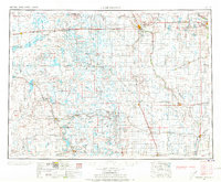
1953 Map of Jamestown
USGS Topo · Published 1973About this map
Jamestown and Valley City anchor this mid-century landscape of the Missouri Plateau, where the sprawling rail networks of the Northern Pacific and the Minneapolis St Paul and Sault Ste Marie define the region's economy. The map illustrates a transition between the undulating plains and the intricate drainage of the James River, dotted with numerous alkaline water bodies such as Chase Lake and Sibley Lake. Historical sites of importance include Whitestone Battlefield State Park, marking an 1863 conflict, and various early conservation efforts like Slade National Wildlife Refuge. Small agricultural settlements like Napoleon, Gackle, and Steele are linked by a grid of early highways and branch rail lines, reflecting the rural development of North Dakota before the widespread expansion of the interstate system.
Find a feature on this map
113 named features on this map. Tap any name to fly to it.
Don’t see what you’re looking for? This feature index may not catch every label — zoom into the map to look around manually.
Map Details
Editions of this 1953 Jamestown Map
3 editions found

Other maps of this area

1894 · Monango
USGS Topo · 1:62,500

1894 · La Moure
USGS Topo · 1:62,500

1894 · Ellendale
USGS Topo · 1:62,500

1894 · Hecla
USGS Topo · 1:62,500

1894 · Savo
USGS Topo · 1:62,500

1894 · Fullerton
USGS Topo · 1:62,500

1894 · Oakes
USGS Topo · 1:62,500

1895 · Lamoure
USGS Topo · 1:125,000

1896 · Columbia
USGS Topo · 1:125,000

1896 · Jamestown
USGS Topo · 1:125,000