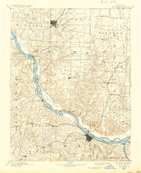
1894 Map of Jefferson City
USGS Topo · Published 1937About this map
The Missouri River bisects this landscape, serving as the primary geographical divider between the developing hubs of Columbia to the north and Jefferson City to the south. In this late nineteenth-century era, the region's economy and settlement patterns are clearly defined by the intersection of river transport and expanding rail lines. The Missouri Pacific Railroad follows the southern bank through Osage City and Centertown, while the Chicago and Alton Railroad cuts across the eastern plains near Guthrie and New Bloomfield. Away from the main river valley, numerous smaller communities like Stephens Store, Millersburg, and Ashland appear as established agricultural centers. The map illustrates a transitional period where river towns such as Marion and Claysville coexist with inland rail-fed settlements, all interconnected by a dense network of creeks including Hinkson Creek and Moreau Creek.
Find a feature on this map
83 named features on this map. Tap any name to fly to it.
Don’t see what you’re looking for? This feature index may not catch every label — zoom into the map to look around manually.
Map Details
Editions of this 1894 Jefferson City Map
4 editions found

Other maps of this area

1886 · Jefferson City
USGS Topo · 1:125,000

1888 · Versailles
USGS Topo · 1:125,000

1888 · Tuscumbia
USGS Topo · 1:125,000

1888 · Boonville
USGS Topo · 1:125,000

1890 · Mexico
USGS Topo · 1:125,000

1890 · Moberly
USGS Topo · 1:125,000

1890 · Glasgow
USGS Topo · 1:125,000

1890 · Fulton
USGS Topo · 1:125,000

1893 · Versailles
USGS Topo · 1:125,000

1894 · Tuscumbia
USGS Topo · 1:125,000