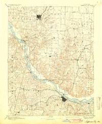
1894 Map of Jefferson City
USGS Topo · Published 1904About this map
The Missouri River meanders through the heart of this late-nineteenth-century landscape, acting as a natural boundary between the growing hubs of Columbia and Jefferson City. The capital city is situated along the southern bank, where the Missouri Pacific Railroad follows the river's path, connecting riverside settlements like Elston and Scruggs. To the north, the terrain transitions into the rolling uplands of Boone County, anchored by the dense grid of Columbia and its connection to the St. Louis and Pacific RR.
Find a feature on this map
86 named features on this map. Tap any name to fly to it.
Don’t see what you’re looking for? This feature index may not catch every label — zoom into the map to look around manually.
Map Details
Editions of this 1894 Jefferson City Map
4 editions found

Other maps of this area

1886 · Jefferson City
USGS Topo · 1:125,000

1888 · Versailles
USGS Topo · 1:125,000

1888 · Tuscumbia
USGS Topo · 1:125,000

1888 · Boonville
USGS Topo · 1:125,000

1890 · Mexico
USGS Topo · 1:125,000

1890 · Moberly
USGS Topo · 1:125,000

1890 · Glasgow
USGS Topo · 1:125,000

1890 · Fulton
USGS Topo · 1:125,000

1893 · Versailles
USGS Topo · 1:125,000

1894 · Tuscumbia
USGS Topo · 1:125,000