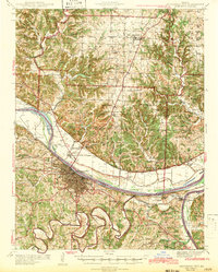
1942 Map of Jefferson City
USGS Topo · Published 1942About this map
Jefferson City serves as the focal point of this mid-century survey, positioned where the Missouri River meets the heavy rail infrastructure of the Missouri Pacific Railroad and the Chicago and Alton Railroad. The map reveals a landscape defined by state institutions and early aviation, notably the State Prison Farm and Algoa Reformatory, alongside the Jefferson City Airport in the river bottomlands.
Find a feature on this map
77 named features on this map. Tap any name to fly to it.
Don’t see what you’re looking for? This feature index may not catch every label — zoom into the map to look around manually.
Map Details
Editions of this 1942 Jefferson City Map
2 editions found

Other maps of this area

1886 · Jefferson City
USGS Topo · 1:125,000

1888 · Tuscumbia
USGS Topo · 1:125,000

1890 · Fulton
USGS Topo · 1:125,000

1894 · Tuscumbia
USGS Topo · 1:125,000

1894 · Jefferson City
USGS Topo · 1:125,000

1928 · Fulton
USGS Topo · 1:62,500

1931 · Fulton
USGS Topo · 1:62,500

1934 · Linn
USGS Topo · 1:48,000

1939 · Jefferson City
USGS Topo · 1:24,000

1939 · Jefferson City
USGS Topo · 1:62,500