
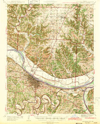
1942 Map of Jefferson City
USGS Topo · Published 1942About this map
The Missouri River corridor anchors this 1942 survey, revealing the capital's mid-century footprint and its reliance on river and rail transport. Jefferson City sits on the southern bluffs, while the north bank is dominated by the floodplains of Cedar City and North Jefferson. This era shows a landscape heavily influenced by state institutions and transit, from the State Prison Farm and Algoa Reformatory to the critical junction of the Missouri Pacific railroad. The map captures the infrastructure of the pre-interstate era, featuring the Jefferson City Airport and original alignments of Highway 54 and Highway 63. To the north and south, the terrain breaks into wooded drainages like Cedar Creek and the Moreau River, dotted with rural schoolhouses like Oak Grove Sch and Halifax Sch that served the outlying farming communities of Guthrie and Summit townships.
Find a feature on this map
79 named features on this map. Tap any name to fly to it.
Don’t see what you’re looking for? This feature index may not catch every label — zoom into the map to look around manually.
Map Details
Editions of this 1942 Jefferson City Map
2 editions found
Other maps of this area

1886 · Jefferson City
USGS Topo · 1:125,000

1888 · Tuscumbia
USGS Topo · 1:125,000

1890 · Fulton
USGS Topo · 1:125,000

1894 · Tuscumbia
USGS Topo · 1:125,000

1894 · Jefferson City
USGS Topo · 1:125,000

1928 · Fulton
USGS Topo · 1:62,500

1931 · Fulton
USGS Topo · 1:62,500

1934 · Linn
USGS Topo · 1:48,000

1939 · Jefferson City
USGS Topo · 1:24,000

1939 · Jefferson City
USGS Topo · 1:62,500