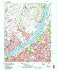
1993 Map of Jeffersonville
USGS Topo · Published 1995About this map
The Ohio River corridor between Indiana and Kentucky is captured here in high detail, showing the industrial and suburban development of the early 1990s. In Indiana, the massive US Military Reservation Indiana Army Ammunition Plant dominates the northern landscape near Utica, while the southern bank in Kentucky features a dense network of neighborhoods like St Matthews and Rolling Fields. The map documents critical infrastructure, from the Clark County Airport and the VA Hospital to the prominent Big Four Bridge spanning the river into the heart of Louisville.
Find a feature on this map
128 named features on this map. Tap any name to fly to it.
Don’t see what you’re looking for? This feature index may not catch every label — zoom into the map to look around manually.
Map Details
Editions of this 1993 Jeffersonville Map
2 editions found
Other maps of this area

1905 · Prospect
USGS Topo · 1:62,500

1907 · Louisville
USGS Topo · 1:62,500

1909 · Kosmosdale
USGS Topo · 1:48,000

1912 · Prospect
USGS Topo · 1:62,500

1912 · Kosmosdale
USGS Topo · 1:62,500

1937 · Jeffersonville
USGS Topo · 1:24,000

1937 · Charlestown
USGS Topo · 1:24,000

1938 · Owen
USGS Topo · 1:24,000

1938 · Speed
USGS Topo · 1:24,000

1939 · New Albany
USGS Topo · 1:24,000