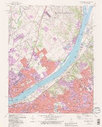
1993 Map of Jeffersonville
USGS Topo · Published 1995About this map
The Ohio River serves as the central artery between Indiana and Kentucky in this mid-1990s record, anchored by the industrial and residential core of Jeffersonville. The Indiana side is dominated by the massive U S Military Reservation Indiana Army Ammunition Plant and the aviation hub of Clark County Airport. Infrastructure connects the states via the Big Four Bridge and John F Kennedy Memorial Bridge, while the river itself is punctuated by islands like Sixmile Island and Towhead Island. On the Kentucky shore, the suburban expansion of St Matthews and affluent enclaves like Glenview are visible alongside significant cultural landmarks. Genealogists and historians can locate the Zachary Taylor National Cem and the Locust Grove Historical Home, providing a window into the region's long-standing heritage. The rail networks of Conrail and CSX Transportation illustrate the enduring importance of this river crossing for midwestern commerce.
Find a feature on this map
137 named features on this map. Tap any name to fly to it.
Don’t see what you’re looking for? This feature index may not catch every label — zoom into the map to look around manually.
Map Details
Editions of this 1993 Jeffersonville Map
2 editions found
Other maps of this area

1905 · Prospect
USGS Topo · 1:62,500

1907 · Louisville
USGS Topo · 1:62,500

1909 · Kosmosdale
USGS Topo · 1:48,000

1912 · Prospect
USGS Topo · 1:62,500

1912 · Kosmosdale
USGS Topo · 1:62,500

1937 · Jeffersonville
USGS Topo · 1:24,000

1937 · Charlestown
USGS Topo · 1:24,000

1938 · Owen
USGS Topo · 1:24,000

1938 · Speed
USGS Topo · 1:24,000

1939 · New Albany
USGS Topo · 1:24,000