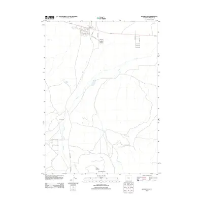
2012 Map of Jeffrey City
USGS Topo · Published 2012About this map
Jeffrey City stands as a central point of interest in this high-desert landscape of central Wyoming. This 2012 survey illustrates a region defined by energy extraction and cattle ranching, with the Crooks Gap Oil Field and Sheep Creek Oil Field indicating the persistent importance of the petroleum industry to the local economy. The town site itself is meticulously detailed, showing a grid of residential and arterial streets such as Coats Rd and Dust Devil Dr that speak to the community's mid-century expansion. To the south, the terrain rises toward the Green Mountains and the prominent Sheep Mountain, while the hydrology is dominated by the wandering courses of Crooks Cr and Sheep Cr. Historically significant properties like the John Kirk Ranch and nearby Kirk Reservoir reflect the deep roots of agricultural land use along the drainage basins of the Great Divide Basin's northern edge.
Find a feature on this map
31 named features on this map. Tap any name to fly to it.
Don’t see what you’re looking for? This feature index may not catch every label — zoom into the map to look around manually.
Map Details
Editions of this 2012 Jeffrey City Map
This is the sole edition of this map. No revisions or reprints were ever made.
Other maps of this area

1951 · Crooks Creek NE
USGS Topo · 1:24,000

1951 · Stampede Meadow
USGS Topo · 1:24,000

1951 · Black Rock Gap
USGS Topo · 1:24,000

1951 · Graham Ranch
USGS Topo · 1:24,000

1951 · Split Rock NW
USGS Topo · 1:24,000

1951 · Crooks Mountain
USGS Topo · 1:24,000

1955 · Casper
USGS Topo · 1:250,000

1957 · Jeffrey City
USGS Topo · 1:24,000

1958 · Casper
USGS Topo · 1:250,000

1961 · Crooks Peak
USGS Topo · 1:24,000