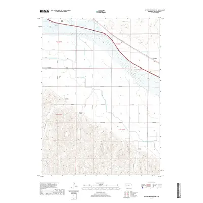
2017 Map of Jeffrey Reservoir NE
USGS Topo · Published 2017About this map
The Platte River dominates this portion of Lincoln County, defining a complex irrigation and transport corridor that includes the Gothenburg Canal, Thirtymile Canal, and the Tri-County Supply Canal. These waterways navigate the transition between the river's broad lowlands and the dissected upland breaks to the south. The small settlement of Vroman sits at the eastern edge of the survey area, while the interior is marked by the rugged topography of Jeffrey Canyon, Gulch Canyon, and Gilman Canyon.
Find a feature on this map
36 named features on this map. Tap any name to fly to it.
Don’t see what you’re looking for? This feature index may not catch every label — zoom into the map to look around manually.
Map Details
Editions of this 2017 Jeffrey Reservoir NE Map
This is the sole edition of this map. No revisions or reprints were ever made.
Other maps of this area

1902 · Gothenburg
USGS Topo · 1:125,000

1954 · McCook
USGS Topo · 1:250,000

1954 · North Platte
USGS Topo · 1:250,000

1956 · North Platte
USGS Topo · 1:250,000

1956 · Jeffrey Reservoir SW
USGS Topo · 1:24,000

1957 · North Platte
USGS Topo · 1:250,000

1957 · McCook
USGS Topo · 1:250,000

1958 · McCook
USGS Topo · 1:250,000

1967 · North Platte
USGS Topo · 1:250,000
1970 · Gothenburg
USGS Topo · 1:24,000