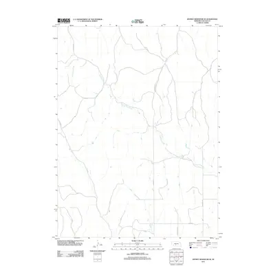
2011 Map of Jeffrey Reservoir SE
USGS Topo · Published 2011About this map
North Plum Creek meanders through the heart of this Lincoln County landscape, defining the local drainage patterns across a section of Nebraska's prairie. This 2011 survey by the U.S. Geological Survey illustrates a rural area organized by a geometric grid of county roads, reflecting the long-standing influence of the Public Land Survey System on the region's development. Local transit and property boundaries are marked by thoroughfares such as S Lydic St and S Gilman Rd, which segment the terrain into large agricultural tracts. The map details the subtle contours of the land around S Mcnickle Rd and S Mcpheeters Rd, providing a precise look at the rural infrastructure as it existed in the early 21st century.
Find a feature on this map
7 named features on this map. Tap any name to fly to it.
Don’t see what you’re looking for? This feature index may not catch every label — zoom into the map to look around manually.
Map Details
Editions of this 2011 Jeffrey Reservoir SE Map
This is the sole edition of this map. No revisions or reprints were ever made.
Other maps of this area

1902 · Gothenburg
USGS Topo · 1:125,000

1954 · McCook
USGS Topo · 1:250,000

1956 · Jeffrey Reservoir SW
USGS Topo · 1:24,000

1956 · Stockville NE
USGS Topo · 1:24,000

1956 · Moorefield
USGS Topo · 1:24,000

1957 · McCook
USGS Topo · 1:250,000

1958 · McCook
USGS Topo · 1:250,000
1970 · Gothenburg
USGS Topo · 1:24,000
1970 · Jeffrey Reservoir SE
USGS Topo · 1:24,000
1970 · Gothenburg SW
USGS Topo · 1:24,000