
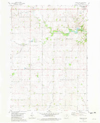
1972 Map of Jerico
USGS Topo · Published 1976About this map
Jerico stands as the primary community in this rural northern Iowa landscape, situated at the crossroads of Chickasaw County's farmland in the early 1970s. The terrain is defined by the winding course of Crane Creek and Spring Creek, which carve through the townships of Paris, Washington, and Jacksonville. The southwestern corner of the quadrangle is marked by the presence of the Chicago and North Western railroad line, which follows the corridor of the East Fork Wapsipinicon River.
Find a feature on this map
13 named features on this map. Tap any name to fly to it.
Don’t see what you’re looking for? This feature index may not catch every label — zoom into the map to look around manually.
Map Details
Editions of this 1972 Jerico Map
This is the sole edition of this map. No revisions or reprints were ever made.
Other maps of this area

1954 · Mason City
USGS Topo · 1:250,000

1957 · Mason City
USGS Topo · 1:250,000

1958 · Mason City
USGS Topo · 1:250,000
1972 · Ionia
USGS Topo · 1:24,000

1972 · Elma
USGS Topo · 1:24,000
1972 · New Hampton
USGS Topo · 1:24,000

1981 · Lourdes
USGS Topo · 1:24,000
1981 · Lawler
USGS Topo · 1:24,000
1981 · Saude
USGS Topo · 1:24,000
1981 · Cresco SW
USGS Topo · 1:24,000