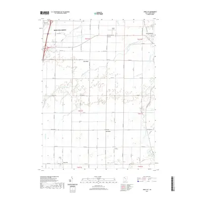
2019 Map of Jerry City
USGS Topo · Published 2019About this map
Bowling Green anchors the northwestern corner of this Wood County landscape, where the flat agricultural terrain is defined by the intricate network of the Portage River system. The land is drained by numerous natural and engineered waterways, including the Middle Branch Portage River, Cuckle Cr, and Rhodes Ditch. Small, long-established communities like Jerry City, Cloverdale, and New Rochester are scattered throughout the township grids of T5N, T4N, and T3N. Local history is well-preserved through several rural burial grounds such as Jerry City Cem, Mount Zion Cem, and the Mennonite Cem. Aviation presence is noted at Shelton Airport and Aring Field, while the rectilinear road network, including the Defiance Pike and Greensburg Pike, highlights the organized settlement pattern typical of northwest Ohio.
Find a feature on this map
76 named features on this map. Tap any name to fly to it.
Don’t see what you’re looking for? This feature index may not catch every label — zoom into the map to look around manually.
Map Details
Editions of this 2019 Jerry City Map
This is the sole edition of this map. No revisions or reprints were ever made.
Other maps of this area

1901 · Fostoria
USGS Topo · 1:62,500

1901 · Bowling Green
USGS Topo · 1:62,500

1901 · Elmore
USGS Topo · 1:62,500

1903 · Bowling Green
USGS Topo · 1:62,500

1903 · Fostoria
USGS Topo · 1:62,500

1903 · Findlay
USGS Topo · 1:62,500

1903 · Elmore
USGS Topo · 1:62,500
1938 · Tontogany
USGS Topo · 1:31,680
1952 · Tontogany
USGS Topo · 1:24,000

1956 · Toledo
USGS Topo · 1:250,000