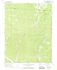
1968 Map of Johnson Mountain
USGS Topo · Published 1969About this map
The Clark National Forest blankets this corner of the Missouri Ozarks, where the boundary between Washington and Iron Counties follows the high ridgelines. The landscape is defined by the headwaters of several significant waterways, including the Big River and the Middle Fork Black River, which carve through the heavily wooded terrain. This 1960s survey documents a quiet rural network of small congregations and family resting places, such as Council Bluff Ch and the Terry Cem.
Find a feature on this map
32 named features on this map. Tap any name to fly to it.
Don’t see what you’re looking for? This feature index may not catch every label — zoom into the map to look around manually.
Map Details
Editions of this 1968 Johnson Mountain Map
3 editions found
Other maps of this area

1906 · Potosi
USGS Topo · 1:62,500

1924 · Edgehill
USGS Topo · 1:62,500

1926 · Edgehill
USGS Topo · 1:62,500

1943 · Berryman
USGS Topo · 1:62,500

1943 · Boss
USGS Topo · 1:62,500

1945 · Berryman
USGS Topo · 1:62,500

1946 · Boss
USGS Topo · 1:62,500

1949 · Rolla
USGS Topo · 1:250,000

1953 · Rolla
USGS Topo · 1:250,000

1954 · Rolla
USGS Topo · 1:250,000