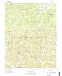
1968 Map of Johnson Mountain
USGS Topo · Published 1977About this map
Clark National Forest and the Kaolin area dominate this 1960s landscape, where the Big River and Middle Fork Black River flow through the interior of the Missouri Ozarks. The map reveals a transition between public timberlands and small rural communities, centered around the settlement of Enough and the winding course of Ottery Creek. Deep within Guyser Hollow and near the steep slopes of Johnson Mountain, the topography is dotted with family-named sites and early industrial markers, including a remote Mine and the Lookout Tower Radio Tower on the heights.
Find a feature on this map
28 named features on this map. Tap any name to fly to it.
Don’t see what you’re looking for? This feature index may not catch every label — zoom into the map to look around manually.
Map Details
Editions of this 1968 Johnson Mountain Map
3 editions found
Other maps of this area

1906 · Potosi
USGS Topo · 1:62,500

1924 · Edgehill
USGS Topo · 1:62,500

1926 · Edgehill
USGS Topo · 1:62,500

1943 · Berryman
USGS Topo · 1:62,500

1943 · Boss
USGS Topo · 1:62,500

1945 · Berryman
USGS Topo · 1:62,500

1946 · Boss
USGS Topo · 1:62,500

1949 · Rolla
USGS Topo · 1:250,000

1953 · Rolla
USGS Topo · 1:250,000

1954 · Rolla
USGS Topo · 1:250,000