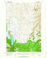
1957 Map of Joseph
USGS Topo · Published 1963About this map
Joseph sits at the foot of the Wallowa Mountains, where the Wallowa River flows north from the depths of Wallowa Lake. This mid-century landscape is defined by a sophisticated network of irrigation, featuring the Farmers Ditch, Silver Lake Ditch, and Moonshine Ditch, which support the agricultural valley around Liberty Grange. Genealogy researchers will find several significant burial sites, including the Chief Joseph Cem near the lake's outlet and the Prairie Cr Cemetery to the east. The industrial and educational infrastructure of the era is well-represented by the Union Pacific Railroad line terminating in town, the Transvaal Mines high in the southern peaks, and local landmarks like Pratt Sch. Higher elevations are dominated by the Wallowa National Forest, where peaks like Mt Howard rise above a wilderness of creeks and ridges.
Find a feature on this map
72 named features on this map. Tap any name to fly to it.
Don’t see what you’re looking for? This feature index may not catch every label — zoom into the map to look around manually.
Map Details
Editions of this 1957 Joseph Map
3 editions found
Other maps of this area

1954 · Cornucopia
USGS Topo · 1:62,500

1954 · Imnaha
USGS Topo · 1:62,500

1954 · Eagle Cap
USGS Topo · 1:62,500

1954 · Harl Butte
USGS Topo · 1:62,500

1955 · Grangeville
USGS Topo · 1:250,000

1957 · Enterprise
USGS Topo · 1:62,500

1957 · Joseph
USGS Topo · 1:62,500

1957 · Homestead
USGS Topo · 1:62,500

1957 · Sled Springs
USGS Topo · 1:62,500

1957 · Elk Mountain
USGS Topo · 1:62,500