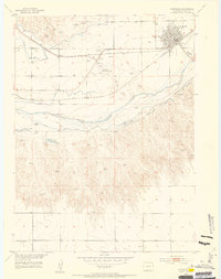
1953 Map of Julesburg
USGS Topo · Published 1954About this map
The town of Julesburg serves as the focal point of this 1950s survey, situated at the vital junction of the Union Pacific railroad and the South Platte River. The map highlights the area's transition from a frontier outpost to an agricultural and transit hub. Evidence of the region's deeper history is visible at Fort Julesburg (Ruins) and a nearby Historical Marker, while the irrigation infrastructure, including the Peterson Ditch and Carlson Ditch, reflects the vital role of water management in the high plains. Farther south, the terrain becomes more varied around Italian Caves and Johnson Lake. This survey captures the mid-century landscape just as certain rural landmarks were fading, notably the Riverside School (Abandoned).
Find a feature on this map
25 named features on this map. Tap any name to fly to it.
Don’t see what you’re looking for? This feature index may not catch every label — zoom into the map to look around manually.
Map Details
Editions of this 1953 Julesburg Map
5 editions found
Other maps of this area

1900 · Chappell
USGS Topo · 1:125,000

1952 · Julesburg SW
USGS Topo · 1:24,000

1952 · Julesburg SE
USGS Topo · 1:24,000

1953 · Ovid
USGS Topo · 1:24,000

1953 · Julesburg
USGS Topo · 1:24,000

1954 · Sterling
USGS Topo · 1:250,000

1954 · Scottsbluff
USGS Topo · 1:250,000

1958 · Scottsbluff
USGS Topo · 1:250,000

1958 · Sterling
USGS Topo · 1:250,000

1961 · Chappell
USGS Topo · 1:24,000