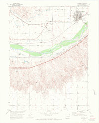
1953 Map of Julesburg
USGS Topo · Published 1972About this map
The town of Julesburg sits at a historic intersection of water and rail in Colorado's northeast corner, where the Union Pacific follows the northern bank of the South Platte River. This early 1950s landscape is defined by an extensive network of irrigation infrastructure designed to harness the river, including the Peterson Ditch, Liddle Ditch, and the Carlson (Aban'd) Ditch. These man-made waterways emphasize the region's agricultural dependency and the complex engineering required to sustain local industry.
Find a feature on this map
24 named features on this map. Tap any name to fly to it.
Don’t see what you’re looking for? This feature index may not catch every label — zoom into the map to look around manually.
Map Details
Editions of this 1953 Julesburg Map
5 editions found
Other maps of this area

1900 · Chappell
USGS Topo · 1:125,000

1952 · Julesburg SW
USGS Topo · 1:24,000

1952 · Julesburg SE
USGS Topo · 1:24,000

1953 · Ovid
USGS Topo · 1:24,000

1953 · Julesburg
USGS Topo · 1:24,000

1954 · Sterling
USGS Topo · 1:250,000

1954 · Scottsbluff
USGS Topo · 1:250,000

1958 · Scottsbluff
USGS Topo · 1:250,000

1958 · Sterling
USGS Topo · 1:250,000

1961 · Chappell
USGS Topo · 1:24,000