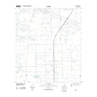
2010 Map of Juliff
USGS Topo · Published 2010About this map
Oyster Creek and the West Fork Chocolate Bayou define the drainage of this coastal prairie landscape south of Houston as it appeared in 2010. The map captures a transition from traditional agricultural and extractive uses to burgeoning residential development. Significant local history sites are concentrated around the older rail and road junctions, including Arcola, Juliff, and Sandy Point. Evidence of the region’s economic drivers is seen in the Arcola Oil Field and the sprawling Darrington State Prison Farm in the southwest quadrant. Flood control measures are visible through the Lake Jackson Levee and Mowery Lake Levee, protecting the low-lying terrain near Lake Jackson. Genealogists will find value in the clearly marked Iowa Colony Cemetery, Sandy Point Cemetery, and Woods Cemetery, which serve as physical anchors for the area's family histories.
Find a feature on this map
82 named features on this map. Tap any name to fly to it.
Don’t see what you’re looking for? This feature index may not catch every label — zoom into the map to look around manually.
Map Details
Editions of this 2010 Juliff Map
This is the sole edition of this map. No revisions or reprints were ever made.
Other maps of this area

1920 · Mykawa
USGS Topo · 1:31,680

1920 · Almeda
USGS Topo · 1:31,680

1943 · Rosharon
USGS Topo · 1:31,680

1943 · Juliff
USGS Topo · 1:31,680

1943 · Chocolate Bayou
USGS Topo · 1:24,000

1950 · Houston
USGS Topo · 1:250,000

1953 · Otey
USGS Topo · 1:24,000

1953 · Thompsons
USGS Topo · 1:24,000
1955 · Pearland
USGS Topo · 1:24,000
1955 · Almeda
USGS Topo · 1:24,000