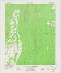
1957 Map of Jumbo
USGS Topo · Published 1977About this map
The Impson Valley serves as the central corridor for this 1957 Pushmataha County survey, where the small settlement of Jumbo is surrounded by a complex network of ridgelines and creek drainages. Significant topographic features including White Rock Mountain, Flat Top Mountain, and Box Springs Mountain define the local elevation, creating a series of narrow valleys where early industrial and agricultural activity took hold. Evidence of resource extraction is present through scattered Oil Wells in the southwest and a Salt Lick positioned between Buck Creek and Spring Branch. Further east, Johns Valley and the smaller settlement of Johns are tucked among the heights of Big Mountain, while curiously named landmarks like Monkeywrench hint at the local lore of this wooded territory. The drainage patterns of Tenmile Creek, Kimbrough Creek, and Horsehead Creek illustrate how the terrain dictated the placement of early roads and homesteads.
Find a feature on this map
33 named features on this map. Tap any name to fly to it.
Don’t see what you’re looking for? This feature index may not catch every label — zoom into the map to look around manually.
Map Details
Editions of this 1957 Jumbo Map
4 editions found
Other maps of this area

1898 · McAlester
USGS Topo · 1:125,000

1901 · Antlers
USGS Topo · 1:125,000

1909 · Mc Alester
USGS Topo · 1:125,000

1912 · Antlers
USGS Topo · 1:125,000

1925 · Antlers
USGS Topo · 1:125,000

1950 · Mcalester
USGS Topo · 1:250,000

1957 · Farris
USGS Topo · 1:24,000

1957 · Moyers
USGS Topo · 1:24,000

1957 · Jumbo
USGS Topo · 1:24,000

1957 · Lane NE
USGS Topo · 1:24,000