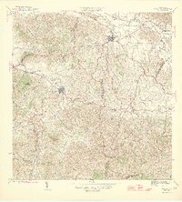
1946 Map of Juncos
USGS Topo · Published 1946About this map
Juncos and San Lorenzo stand as the primary urban centers in this mid-century portrait of eastern Puerto Rico, where the agricultural landscape is heavily influenced by the sugar industry. Large land tracts like those of Central Juncos Associates and Eastern Sugar Associates flank the Rio Gurabo, illustrating the economic dominance of sugar production in the valley. The terrain rises sharply to the south and east, reaching the edges of the Caribbean National Forest and prominent peaks such as Cerro Santa Ana. Rural life is anchored by landmarks like the Escuela Segunda Unidad de Quebrada Honda and small settlements like El Mango. The map traces a complex network of waterways, including the Rio Grande de Loiza and numerous creeks such as Quebrada Salvatierra and Quebrada Honda, which define the municipal boundaries and local geography.
Find a feature on this map
27 named features on this map. Tap any name to fly to it.
Don’t see what you’re looking for? This feature index may not catch every label — zoom into the map to look around manually.
Map Details
Editions of this 1946 Juncos Map
3 editions found
Other maps of this area

1945 · El Yunque
USGS Topo · 1:30,000

1946 · Patillas
USGS Topo · 1:30,000

1946 · El Yunque
USGS Topo · 1:30,000

1946 · Aguas Buenas
USGS Topo · 1:30,000

1946 · Humacao
USGS Topo · 1:30,000

1946 · Punta Guayanes
USGS Topo · 1:30,000

1946 · Gurabo
USGS Topo · 1:30,000

1946 · Juncos
USGS Topo · 1:30,000

1946 · Yabucoa
USGS Topo · 1:30,000

1946 · Caguas
USGS Topo · 1:30,000
Featured Places
- San Lorenzo
- Juncos
- Cinco Cuerdas, Las Piedras
- Sector Carmita Torres, Las Piedras
- Colinas de Navarro, Gurabo